Changes to the map screen for next patch
This is just a bit of information for any map makers.
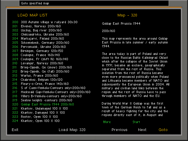
The Load and Save map screens will be changed considerably for the next patch. Not only have we moved to a "flat screen" layout similar to the scenario editing screen but we now read text files written for the maps as well. This was inspired in many ways by the existence and continuing development of the Vehola map generator
http://www.venhola.com/maps/
This is an example of the screen

Map names and numbers are to the left and there is room on the right for text so now anyone who spends the time to build a map ( and I well know how long that can take and the work involved ) you can issue a TXT file along with your map explaining whatever it is you want to explain or point out.... Latitude and Longitude could be one thing or any relevant historical information and it allows map makers to sign their work . Most of the maps in the game are " anonymous " because short of signing the map directly there is no way to know who spent the time to build it and we would like to correct that
Adding text is simple...... the txt file uses the same name as the map file and goes into the map folder so spmap320.dat already has a spmap320.cmt and you would create a spmap320.txt as well and that will show up on the new map screen.
Editing the text is straightforward with a couple of simple and easy to remember rules.......
1/ No non-standard characters (accents, tildes, umlauts, etc.) so nothing like any of these
â, ê, î, ô, û, ŵ, ŷ, ä, ë, ï, ö, ü, ẅ, ÿ, à, è, ì, ò, ù, ẁ, ỳ, á, é, í, ó, ú, ẃ, ý...the game font code is not set up to handle it and weird and ( less than ..) wonderful things can happen that usually involved fragmenting the text
2/ End a paragraph with a '
*' and leave a gap between the paragraphs with a '
*' as well. This tells the game to end and leave a space
3/ anything with %
has to be done twice like so.....90%%
The example shown above is set up in part like this
Quote:
Goldap East Prussia 1944 *
*
200x160*
*
This map represents the area around Goldap East Prussia in late summer / early autumn 1944.*
*
The area today is part of Poland and very close to the Russian Baltic Kaliningrad Oblast which after the collapse of the Soviet Union in 1991, became an exclave, geographically separated from the rest of Russia. This isolation from the rest of Russia became even more pronounced politically when Poland and Lithuania became members of NATO and subsequently the European Union in 2004. All military and civilian land links between the region and the rest of Russia have to pass through members of NATO and the EU. *
*
|
also, note the CD owners can use the GOTO feature that will take you directly to the map you want without having to click-click-click-click-click-click-click-click- to get there..just enter the number and press enter


